


Ocean township voting district 2, Ocean County, New Jersey
About
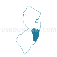
Outline

Summary
| Unique Area Identifier | 621312 |
| Name | Ocean township voting district 2 |
| County | Ocean County |
| State | New Jersey |
| Area (square miles) | 24.94 |
| Land Area (square miles) | 13.67 |
| Water Area (square miles) | 11.27 |
| % of Land Area | 54.81 |
| % of Water Area | 45.19 |
| Latitude of the Internal Point | 39.78851310 |
| Longtitude of the Internal Point | -74.19708430 |
Maps


Graphs
Select a template below for downloading or customizing gragh for Ocean township voting district 2, Ocean County, New Jersey


Neighbors
Neighoring Voting District (by Name) Neighboring Voting District on the Map
- Barnegat Light borough voting district 1, Ocean County, NJ
- Barnegat township voting district 1, Ocean County, NJ
- Barnegat township voting district 11, Ocean County, NJ
- Barnegat township voting district 2, Ocean County, NJ
- Barnegat township voting district 5, Ocean County, NJ
- Barnegat township voting district 7, Ocean County, NJ
- Barnegat township voting district 8, Ocean County, NJ
- Barnegat township voting district 9, Ocean County, NJ
- Berkeley township Island Beach State Park, Ocean County, NJ
- Lacey township voting district 10, Ocean County, NJ
- Lacey township voting district 17, Ocean County, NJ
- Lacey township voting district 6, Ocean County, NJ
- Long Beach township voting district 3, Ocean County, NJ
- Ocean township voting district 1, Ocean County, NJ
- Ocean township voting district 3, Ocean County, NJ
- Ocean township voting district 4, Ocean County, NJ
- Ocean township voting district 5, Ocean County, NJ
Top 10 Neighboring County Subdivision (by Population) Neighboring County Subdivision on the Map
- Berkeley township, Ocean County, NJ (41,255)
- Lacey township, Ocean County, NJ (27,644)
- Barnegat township, Ocean County, NJ (20,936)
- Ocean township, Ocean County, NJ (8,332)
- Long Beach township, Ocean County, NJ (3,051)
- Barnegat Light borough, Ocean County, NJ (574)
Top 10 Neighboring Place (by Population) Neighboring Place on the Map
Top 10 Neighboring Elementary School District (by Population) Neighboring Elementary School District on the Map
- Berkeley Township School District, NJ (41,255)
- Barnegat Township School District, NJ (20,936)
- Ocean Township School District, NJ (8,332)
- Long Beach Island School District, NJ (6,323)
Top 10 Neighboring Secondary School District (by Population) Neighboring Secondary School District on the Map
Top 10 Neighboring Unified School District (by Population) Neighboring Unified School District on the Map
Top 10 Neighboring State Legislative District Lower Chamber (by Population) Neighboring State Legislative District Lower Chamber on the Map
Top 10 Neighboring State Legislative District Upper Chamber (by Population) Neighboring State Legislative District Upper Chamber on the Map
Top 10 Neighboring 111th Congressional District (by Population) Neighboring 111th Congressional District on the Map
Top 10 Neighboring Census Tract (by Population) Neighboring Census Tract on the Map
- Census Tract 7330, Ocean County, NJ (8,330)
- Census Tract 7340.01, Ocean County, NJ (7,185)
- Census Tract 7340.02, Ocean County, NJ (6,301)
- Census Tract 7320.01, Ocean County, NJ (5,807)
- Census Tract 7321.04, Ocean County, NJ (4,170)
- Census Tract 7381, Ocean County, NJ (1,526)
- Census Tract 9800, Ocean County, NJ (5)
Top 10 Neighboring 5-Digit ZIP Code Tabulation Area (by Population) Neighboring 5-Digit ZIP Code Tabulation Area on the Map
- 08005, NJ (22,448)
- 08731, NJ (20,009)
- 08758, NJ (7,043)
- 08008, NJ (6,975)
- 08752, NJ (2,074)
- 08006, NJ (518)